Heat alerts are back! This means it will feel very hot over the next several days so drink plenty of water. In the tropics, a disturbance in the northeastern Gulf continues to grow more organized.

Tonight & Tomorrow: It has been a hot one today. Temperatures will cool into the mid-70s overnight under mostly clear skies. Another Heat Advisory has been posted for Sunday. This goes into effect at 10am, and lasts until 6pm. Highs in the mid-90s plus high humidity will send our peak heat index near 110°. These type of conditions could cause heat illness, so drink plenty of fluids and take frequent breaks if outside. Skies will be mostly sunny once again, and almost everyone will stay dry.
Up Next: Intense heat is expected all week long, and it is possible we see a heat alert each and every day. Extreme Heat Warnings will be possible, meaning heat index values could climb above 113° at times. As for rain, a tropical disturbance currently located in the northeastern Gulf has introduced a bit of uncertainty. If this disturbance gets close enough, it is possible that our rain chances uptick Monday through Wednesday thanks to high tropical moisture. This scenario is a bit uncertain, so have opted for a 20% rain coverage each of those days for now. More on the tropical disturbance can be found in The Tropics section below. By the end of the week into the weekend, we should observe a fairly typical summer pattern. This means hot and humid conditions, with pop-up storms in the afternoon.
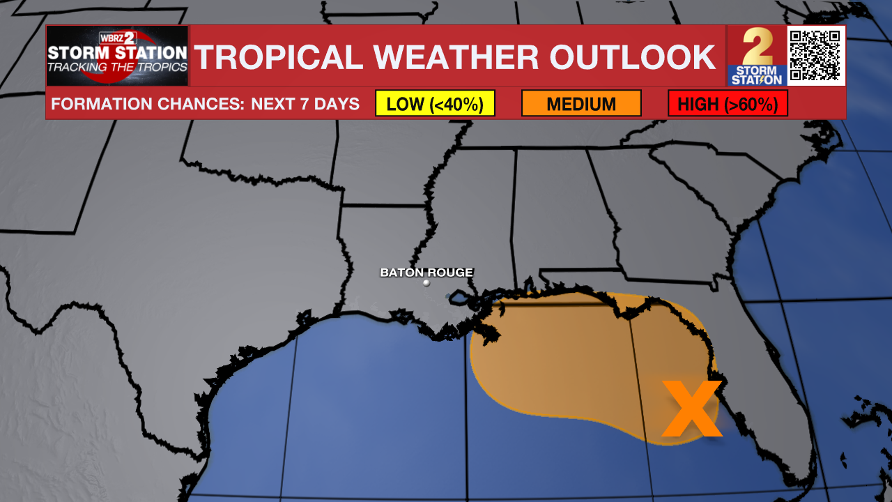
The Tropics: Satellite images and surface observations indicate that a broad surface low is forming over the eastern Gulf. However, the associated winds remain light, and the showers and thunderstorms are still disorganized. Gradual development of this system is possible, and it could become a tropical depression while it moves slowly northward or north-northwestward during the next few days. Interests along the Florida Gulf coast, southern Alabama, and southwestern Georgia should monitor the progress of this system as it is expected to bring heavy rain to portions of that region during the next several days. An Air Force Reserve reconnaissance aircraft is scheduled to investigate the system on Sunday, if needed.
Get the latest 7-day forecast and real-time weather updates HERE.
Watch live news HERE.
– Balin
The Storm Station is here for you, on every platform. Your weather updates can be found on News 2, wbrz.com, and the WBRZ WX App on your Apple or Android device. Follow WBRZ Weather on Facebook and X for even more weather updates while you are on the go.