

Latest Weather Blog
Tropical Storm Watches in place for parts of the Louisiana coast, heavy rain threat continues
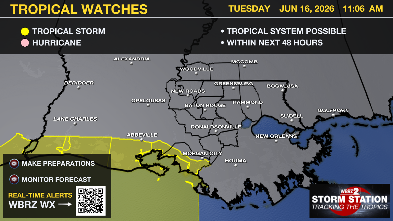
Tropical Storm Watches have been issued along the central Gulf Coast, extending from the east Texas coastline to St. Mary Parish. The National Hurricane Center has also started issuing forecasts for Potential Tropical Cyclone One.
The "potential tropical cyclone" terminology is used when a disturbance does not meet the criteria to be a tropical depression or storm, but could do so and affect land shortly. This allows the National Hurricane Center to begin issuing alerts and forecasts ahead of landfall. It's important to note that tropical development does not always occur with these. Regardless of the outcome locally, the impact remains the same: heavy rain associated with tropical downpours is likely this week.

While slowly moving now, the system will speed up over the next couple of days, moving offshore Texas late Tuesday into Wednesday. It will track parallel to the upper Texas coast on Wednesday before moving back inland over eastern Texas or southwestern Louisiana late Wednesday or early Thursday. As of Tuesday morning, maximum sustained winds were near 30 mph with higher gusts; however, gradual strengthening is forecast, and the system could become a tropical storm by early Wednesday. Should that occur, the system would be called Tropical Storm Arthur
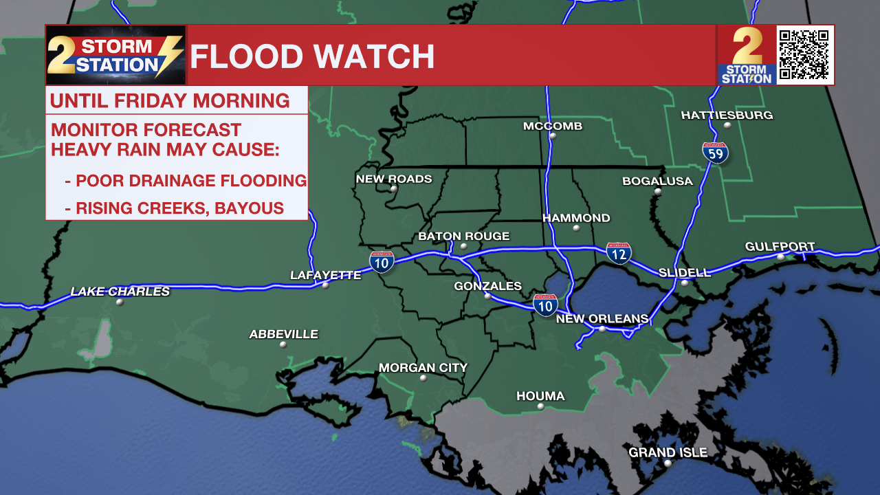
A FLOOD WATCH remains in effect for the entire Capital Region through Friday morning. A FLASH FLOOD WATCH means conditions may develop that lead to flash flooding. Flash flooding is a very dangerous situation. Be on the lookout for threatening weather conditions and listen for later statements and possible warnings. For more on flooding safety, CLICK HERE.
Trending News
A tropical disturbance will send very high moisture content our way, causing multiple rounds of heavy rainfall to our region through Friday. Widespread accumulation is expected to average between 4 and 7 inches across the board. However, localized bullseyes could easily exceed 10 inches before the system clears out. While you should expect wet weather every single day this week, Tuesday and Thursday present the best setup for heavy rainfall. These two days carry our highest vulnerability for flash flooding.
Today & Tonight: Expect a rather messy drive for your Tuesday morning commute, so be sure to budget some extra travel time for slick roads. If you are hoping for a break in the weather today, dry hours will be few and far between. Following our initial morning wave of precipitation, a steady stream of moisture will fuel widespread showers and thunderstorms right through the afternoon. Because these storms will be highly efficient rain producers, continuous heavy downpours will likely cause water to pond on roadways and collect in low-lying areas, making isolated flash flooding a distinct possibility as the day progresses. Please exercise extra caution behind the wheel, as virtually our entire region will see measurable rainfall today. On the plus side, the extensive cloud cover and persistent rain will cap our high temperatures safely in the upper 70s to low 80s. As we head into the overnight hours, the overall coverage of the rain will gradually trend downward, though it won't clear out entirely. Scattered showers will linger as temperatures dip into the mid-70s, meaning you should plan ahead for the possibility of another damp and slow commute come Wednesday morning.

Use the slider to advance through the next 24 hours of Futurecast
Up Next: Although Wednesday offers a brief reprieve with a bit of a drop in overall storm coverage, you should still expect to dodge scattered downpours from time to time. Our attention then shifts to Thursday, which looks to be quite active as a tropical disturbance tracks directly through the region. While the National Hurricane Center currently highlights this system with a medium probability for tropical development, its classification won't change the ground reality for us: we are looking at an influx of deep tropical moisture capable of producing exceptionally high rainfall rates. Given how saturated the ground will be from our early-week rainfall, Thursday's setup poses a more significant threat for flash flooding. We will also need to keep a close eye on area river gauges, though thankfully there are no immediate flooding concerns for our waterways just yet. This tropical disturbance will begin to pull away by Friday, but it will drag a stalled frontal boundary back into the area to keep heavy rain in the forecast for one more day. Fortunately, looking ahead to Father’s Day Weekend, the atmosphere begins to stabilize, allowing rain chances to steadily step down just in time for holiday plans.


Get the latest 7-day forecast and real-time weather updates HERE.
Watch live news HERE.
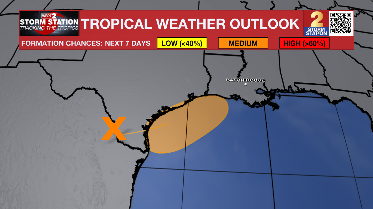
The Tropics: A disturbance over northeastern Mexico will re-emerge over the northwest Gulf late Tuesday or Wednesday. Once over open water, it now appears to have a 60% chance of tropical development before moving inland by Thursday. The National Hurricane Center specifically notes that “Tropical Storm Watches or Warnings could be required on Tuesday.” Regardless of formation, heavy rainfall and flash flooding are likely across the central Gulf Coast, including the Capital Area.
— The Storm Station Meteorologists
The Storm Station is here for you, on every platform. Your weather updates can be found on News 2, wbrz.com, and the WBRZ WX App on your Apple or Android device. Follow WBRZ Weather on Facebook and X for even more weather updates while you are on the go.
More News
