

Latest Weather Blog
Wednesday morning video forecast
Related Story
The trend of cooler mornings and no humidity will not last for long. Increasing atmospheric moisture will lead to more humidity, higher low temps, patchy fog, and rain chances heading into the weekend.
Today & Tonight: Thankfully we will have another pleasant and comfortable morning across the Capital Area. During the day, it will be warm with highs near 88 degrees. This is a good bit above average for this time of year. The good news is humidity will be on the low side. Dry air will lead to complete and total sunshine. Overnight, lows will bottom out near 62 degrees. Patchy fog will be possible.
Up Next: The end of the week will bring a noticeable change in the feel of the air as humidity begins to climb again. By Thursday, winds will turn from the east to the southeast, ushering in a more humid air off the Gulf. That increase in moisture could lead to some early-morning fog, especially between Thursday and Saturday.
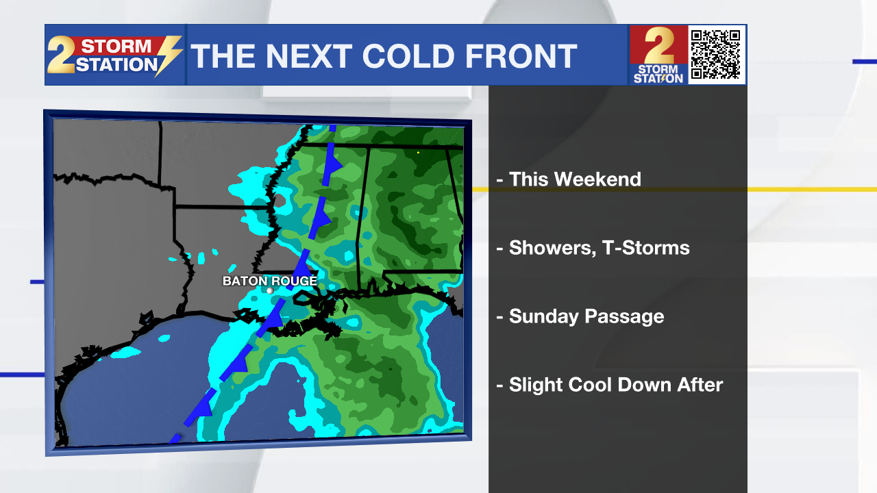
Heading into the weekend, the next weather shift takes shape. A cold front will approach the Gulf Coast, serving as the trigger for scattered showers and thunderstorms. Clouds will thicken late Saturday, with rain chances lingering into early Sunday before the front moves through.
There’s still a bit of uncertainty on timing — some models push the front through Saturday night, others hold off until Sunday morning — but either way, outdoor plans may need an indoor contingency plan. Still, both days should offer plenty of dry time, and no full washouts are expected. Once the front passes, drier and slightly cooler air returns, with highs easing back into the mid-80s and mornings dipping into the low 60s by early next week.
The Tropics: Lorenzo has flared up a bit overnight, showing more thunderstorm activity, but satellite images indicate the storm’s structure is stretching out north to south as it gets caught in stronger winds high in the atmosphere. Winds are estimated around 40 mph. The storm is now moving north and is expected to pick up speed and curve northeast later today as it gets pulled along by those upper-level winds. Forecast models show it staying on that path until it weakens completely. Strong wind shear and dry air are expected to tear the system apart within the next day or so, and Lorenzo could fizzle out even sooner than that.
Get the latest 7-day forecast and real-time weather updates HERE.
Watch live news HERE.
– Balin
The Storm Station is here for you, on every platform. Your weather updates can be found on News 2, wbrz.com, and the WBRZ WX App on your Apple or Android device. Follow WBRZ Weather on Facebook and X for even more weather updates while you are on the go.
News
