

Latest Weather Blog
NEW: Damage surveys confirm two additional tornadoes in Capital Area from weekend storms
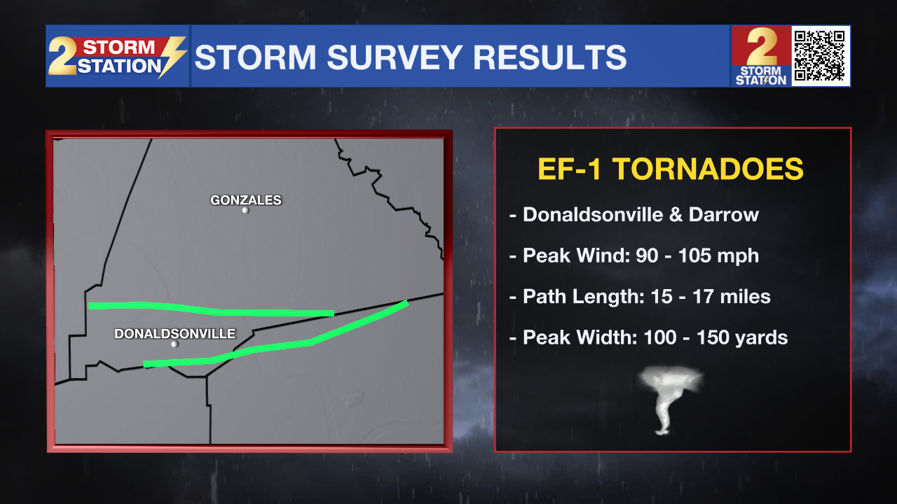
Additional survey crews assessed damage across southern Louisiana on Tuesday that was left behind by weekend storms. Officials determined that two tornadoes tracked through portions of Ascension and St. James Parish. This brings the total number of tornadoes within the Storm Station coverage area to four, after two tornadoes were confirmed in Amite and Wilkinson Counties on Monday.
Donaldsonville/Union, LA: EF-1 Tornado
• Estimated Peak Wind: 105 mph
• Path Length: 17.3 miles
• Maximum Path Width: 200 yards
• Start: 2 miles SW Donaldsonville (Ascension Parish, LA)
• End: 6 miles NNW Lutcher (St. James Parish, LA)
Trending News
Survey Findings: An NWS storm survey team determined that an EF-1 tornado with peak winds of 105 mph, embedded within a line of storms, touched down shortly after midnight on February 14 just north of the Ascension/Assumption Parish line. The tornado began by snapping large branches and uprooting a tree near Te Nom Landry Road and Highway 308 South. It then moved east-northeast across open fields toward the intersection of Highway 3089 and Highway 70. At that location, the tornado strengthened to EF-1 intensity, snapping a power pole and a tree trunk. Maintaining EF-1 strength, the tornado continued east-northeast, snapping a series of power lines along Baxter Road on the south side of the CF Industries complex. It intensified further to peak intensity as it crossed into St. James Parish, moving primarily through open fields before snapping four power lines in another open field. The tornado remained strong as it crossed an additional field near Badger Road and snapped another set of power lines along Highway 18. It then began to weaken as it moved east-northeast across the Mississippi River. Near Highway 3125, it partially snapped and bent another power line. The tornado tracked into marshland north of Highway 3025 before reaching Highway 61, where it uprooted another tree. The final damage point was along Interstate 10, where additional large branches were snapped. This track is preliminary and may be adjusted following further review of high-resolution satellite imagery in the coming weeks.
Hillaryville, LA: EF-1 Tornado
• Estimated Peak Wind: 90 mph
• Path Length: 15.3 miles
• Maximum Path Width: 150 yards
• Start: 4 miles ESE White Castle (Ascension Parish, LA)
• End: 4 miles SSE Sorrento (Ascension Parish, LA)
Survey Findings: An NWS storm survey team determined that an EF-1 tornado with peak winds of 90 mph, embedded within a line of storms, touched down just after midnight on February 15 along Highway 1 in far western Ascension Parish. The tornado initially snapped large branches and small tree trunks before continuing eastward, causing minor tree damage as it crossed Highway 405 and the Mississippi River. Additional damage to large branches and treetops was observed along River Road north of Darrow. The tornado moved east-southeast across inaccessible areas until reaching Ruffin Martinez Road and Highway 22, where more large branches were snapped as it continued toward Walter Hill Road. It then crossed the Mississippi River a second time, remaining over open fields or a refinery. The tornado reached peak intensity near Highway 70, where a few tree trunks were snapped. It then tracked east of Highway 70 over marshland, likely lifting near the Ascension/St. James Parish line. This track is preliminary and may be adjusted following further review of high-resolution satellite imagery in the coming weeks.
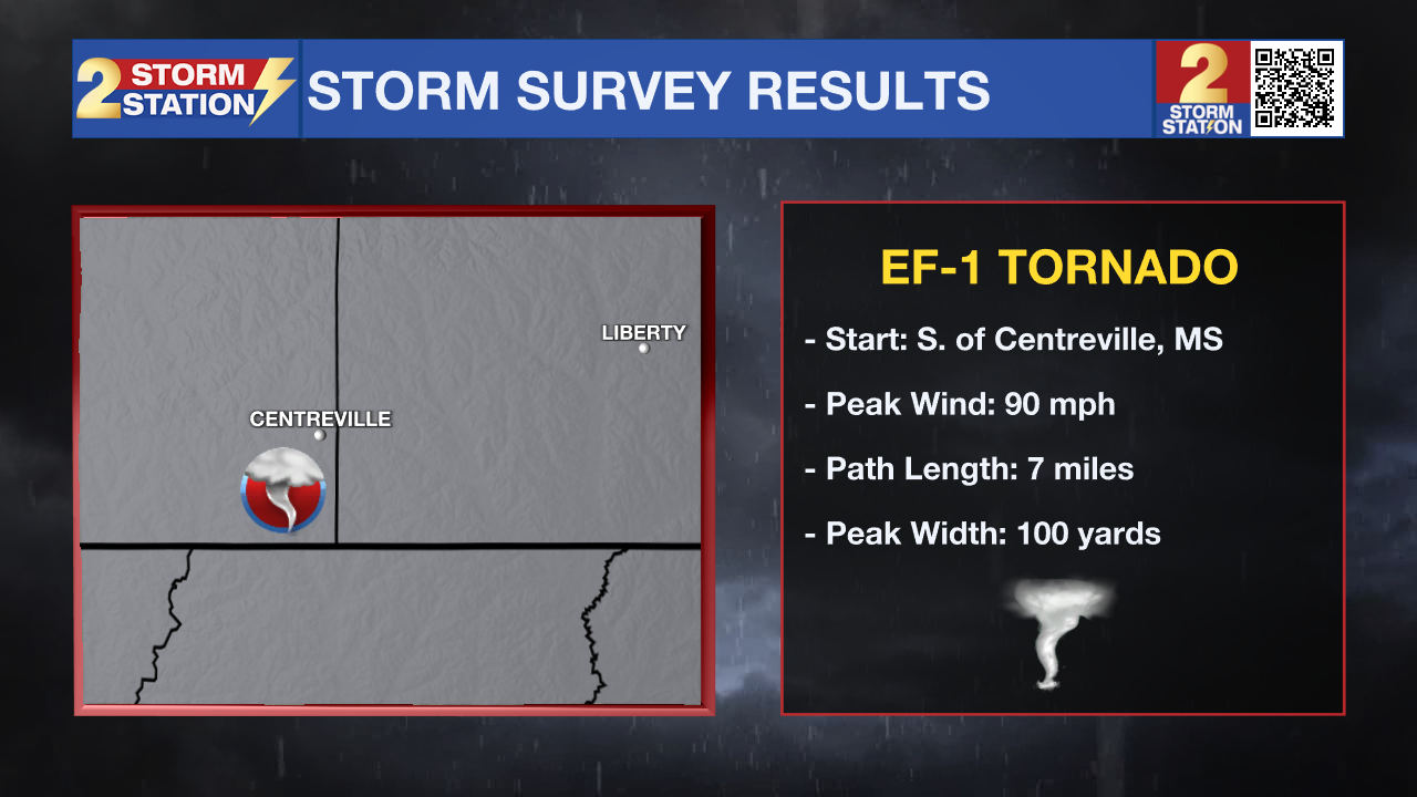
Centreville, MS: EF-1 Tornado
• Estimated Peak Wind: 90 mph
• Path Length: 7 miles
• Maximum Path Width: 100 yards
• Start: 6 miles NNW Norwood (Wilkinson County, MS)
• End: 1 mile ESE Centreville (Amite County, MS)
Survey Findings: An EF-1 tornado touched down along Ancil Cox Road on the southwest side of Centerville near Griffin Lane. A few trees were downed, including at least one that brought down a power line. The tornado tracked northeast, roughly paralleling Ancil Cox Road, reaching Old Highway 33. The most significant damage occurred near this intersection, where about a dozen trees were uprooted or snapped, supporting the 90 mph wind rating. Beyond this point, the tornado continued northeast, causing sporadic tree and limb damage. The final accessible point along its path was near Centerville Academy, where minor damage was observed, including a downed light pole, partial roof uplift on a metal building, and a baseball pitching backstop thrown roughly 250 feet into a chain-link fence. The tornado may have continued slightly farther northeast, but confirmation will require further satellite imagery analysis.
Peoria, MS: EF-1 Tornado
• Estimated Peak Wind: 90 mph
• Path Length: 2.3 miles
• Maximum Path Width: 100 yards
• Start: 7 E Liberty (Amite County, MS)
• End: 8 ENE Liberty (Amite County, MS)
Survey Findings: An EF-1 tornado with peak winds of 90 mph touched down along Peoria Road, about 1 mile south of Highway 24. Dozens of trees were snapped and uprooted at the initial damage site. The severity of tree damage suggests the tornado may have first touched down slightly southwest of this location; however, limited access in the rural area prevented confirmation of an extended path. The tornado tracked northeast, crossing Highway 24 and East Fork Road, producing numerous snapped and uprooted trees along this segment. It may have continued beyond the surveyed area, and additional satellite imagery analysis will be conducted to determine the full extent of the path.

Meteorologist Balin Rogers was on-air continuously for several hours on Saturday night, covering multiple Tornado Warnings.
The Storm Station is here for you, on every platform. Your weather updates can be found on News 2, wbrz.com, and the WBRZ WX App on your Apple or Android device. Follow WBRZ Weather on Facebook and X for even more weather updates while you are on the go.
More News
