

Latest Weather Blog
Saturday PM Forecast: Humidity to take a dip the next several days
A weak front will cause the extreme humidity values we have been experiencing to take a tumble. Expect noticeable humidity changes for the 2nd half of the weekend, and early next week.
Tonight & Tomorrow: Very few storms have formed today, but the ones that did develop will quickly fizzle out after sunset. Expect a mainly clear night, with lows near 71 degrees. Front number one will finally push into the northern Gulf Sunday. Really dry air on the backside will lead to mostly sunny skies, and lower humidity! Now it will still be hot, with highs in the mid-90s, but our heat index might stay below the triple digits. Afternoon storms will be very minimal, with almost everyone staying dry.
Up Next: These conditions will stick around on Monday, before we start to see some slight changes Tuesday, as front number two approaches. Moisture will pool ahead of this front, causing a slight rise in humidity, and a slightly greater chance of afternoon storms. There is a tad of uncertainty on if or when this 2nd front passes, but the Storm Station is leaning towards a Tuesday night passage based on new data. This will lead to another big shot of dry air for Wednesday and Thursday. Humidity levels will dive once again, with rain chances very minimal. Unfortunately, just like the first front, temperatures will have little to no change. A few locations could sneak into the upper 60s some nights. Changing wind direction will allow moisture to build as we head into the weekend. Greater rain chances and humidity is set to return by this point.
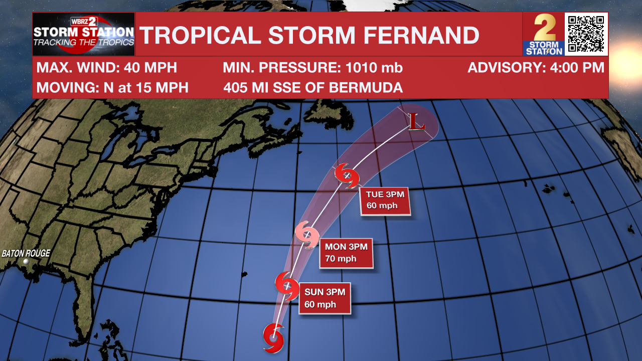
The Tropics: Tropical Storm Fernand has recently formed in the southwestern Atlantic. It has winds of 40 mph, and is moving north at 15 mph. Fernand will gradually pick up speed, turning northeast in the next couple of days. The system has a window of about 48 hours over warm water to strengthen and could come close to hurricane strength, though dry air may limit how strong it gets. By early next week, the storm is expected to weaken as it moves into cooler waters and stronger winds aloft, likely losing its tropical characteristics within 3–4 days. Fernand is no threat to the mainland U.S.
Trending News
Showers and thunderstorms continue in association with a tropical wave located about 650 miles east of the Windward Islands. Some development of this system could occur during the next couple of days while the system moves quickly westward at about 20 to 25 mph. Locally heavy rainfall and gusty winds are possible across portions of the Windward Islands as the system moves through on Sunday and Monday. By Tuesday, conditions over the central Caribbean are expected to be unfavorable for further development.
Get the latest 7-day forecast and real-time weather updates HERE.
Watch live news HERE.
– Balin
The Storm Station is here for you, on every platform. Your weather updates can be found on News 2, wbrz.com, and the WBRZ WX App on your Apple or Android device. Follow WBRZ Weather on Facebook and X for even more weather updates while you are on the go.
More News
