

Latest Weather Blog
Thursday AM Forecast: Chilly start this morning, stormy weekend ahead
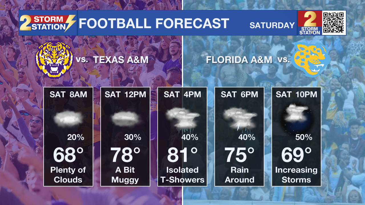
Jackets are advised this morning as temperatures are in the upper 40s and lower 50s! Looking ahead to the weekend, our next storm system could create some issues for both LSU and Southern home games.
Today, Tonight, & Friday: After the chilly morning start, temperatures will climb into the lower 80s by the afternoon. Some higher level clouds will cause for some filtered sunshine. Overnight, lows will come up a tad, bottoming out near 54 degrees. Friday will continue the pleasant weather, with highs in the lower 80s and mostly sunny skies.
Friday Night Blitz: If heading out Friday evening to catch some high school football games, the weather will cooperate! Temperatures will cool through the 70s during the games, possibly reaching the 60s in some neighborhoods, so you might want to take an extra layer.
Weekend: A developing storm system to the west will eventually arrive over the weekend, creating some stormy weather. Based on latest data from this morning, we will likely see multiple rounds of storms, with hit-and-miss action in between. The timing of these rounds is still the trickiest part of this forecast. Round #1 could arrive as early as Saturday afternoon. If it gets out of here early enough, LSU and Southern home games might only have to deal with a few passing showers and storms. That is the hope, but it is certainly not guaranteed given the lingering uncertainty.
Trending News
As we head further into the overnight hours, rain chances will drastically increase as a low pressure system and warm front approaches. One final round will move through early on Sunday morning until we start to clear out for the 2nd half of your Sunday. The overnight round and early on Sunday morning is likely where the heaviest rain will fall. A stronger storm is not out of the question as well. 1-3" of rain is expected through the weekend, but isolated higher totals are possible.
Next Week: Rain chances will start to taper off early next week as the atmosphere becomes less favorable for widespread activity. Still, enough warmth and humidity will linger to allow for a few spotty showers on Monday and Tuesday. Afternoon highs will stay in the 80s with overnight lows in the 60s. A stronger cold front is expected to arrive by midweek, bringing a more noticeable drop in temperatures. As we approach Halloween, highs could dip into the low 70s with morning lows falling into the upper 40s — below average for this time of year.

The Tropics: Melissa is still struggling to organize due to strong upper-level winds pushing against it. The storm remains tilted, with most of its stronger winds on the east side, and its 50 mph strength estimate may be a bit high. Movement has been slow and erratic, but it should drift north before turning west or northwest this weekend, likely staying near Haiti, Jamaica, and eastern Cuba for several days. Wind shear is expected to ease soon, and with warm Caribbean waters ahead, Melissa could strengthen quickly this weekend and early next week as it becomes more organized. A major hurricane is now explicitly in the forecast.
Get the latest 7-day forecast and real-time weather updates HERE.
Watch live news HERE.
– Balin
The Storm Station is here for you, on every platform. Your weather updates can be found on News 2, wbrz.com, and the WBRZ WX App on your Apple or Android device. Follow WBRZ Weather on Facebook and X for even more weather updates while you are on the go.
More News
