

Latest Weather Blog
Wednesday AM Forecast: One last mainly dry day before a stormy stretch begins
Wednesday marks the final day of mainly dry conditions across the Baton Rouge region. Heading into Thursday and Friday, a pattern change will take hold as deep tropical moisture flows into Southeast Louisiana. This setup will destabilize the air mass, bringing rain and thunderstorms through the end of the week and weekend, along with a risk of localized standing water on roadways.

Today & Tonight: You won't need an umbrella just yet, as quiet weather holds across the area through Wednesday. Abundant sunshine will push daytime highs into the lower 90s, though relatively dry air will keep heat index values comfortably below 100°. Moisture rapidly rebounds after dark, however, holding nighttime temperatures around 73° and setting the stage for a muggier trend.
Up Next: The increase in moisture on Thursday will lead to scattered showers and thunderstorms popping in the afternoon and evening. Highs will reach the low 90s with mugginess back in full force.
Trending News
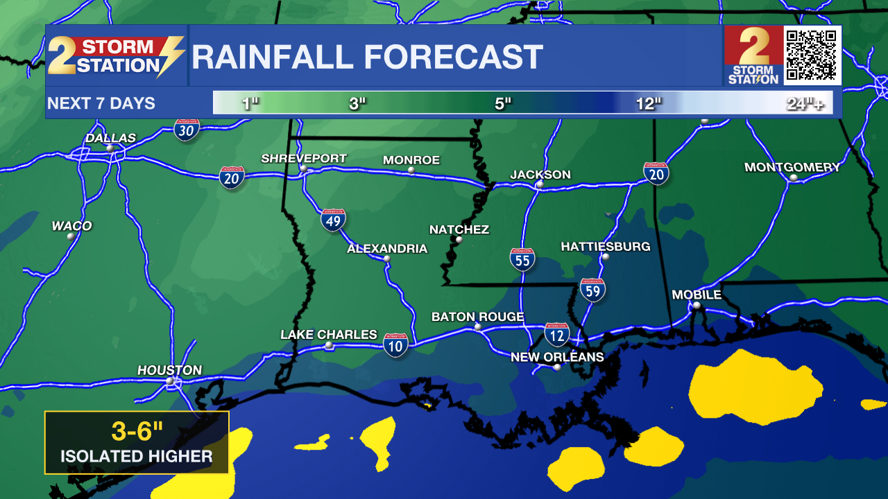
Atmospheric instability builds significantly late this week, setting up a wet weather pattern for the weekend. Deep tropical moisture originating from a Caribbean wave will push into our region, combining with a surface front advancing from the west. Atmospheric moisture levels will climb near historical maximums for this time of year, creating an environment capable of producing heavy rain across the region Friday through Sunday. While pinpoint timing for specific outdoor events and weekend games remains uncertain, key forecast details include:
• Rain Coverage: Expect a 60% coverage of showers and storms on Friday, with coverage increasing to 70% on Saturday and Sunday. Storms will be numerous at times, but some spots could miss out on the rain. All day washouts are not expected.
• Accumulation & Flooding Risks: Widespread rainfall totals of 3 to 6 inches are anticipated across the area. Thunderstorms could yield localized hourly rates exceeding 4 inches. This could overwhelm drainage systems and cause flash flooding in localized areas. Fortunately, bayous and rivers are currently very low and should handle the runoff without major flooding concerns.
• Temperature Outlook: Persistent mainly cloudy skies and rainfall will cap afternoon highs in the mid-to-upper 80s, while elevated moisture values will maintain muggy overnight lows around 73°.
Rain chances taper off slowly early next week. Looking further ahead, guidance hints at a potential cold front just beyond the 7-day forecast that could deliver the season's first very noticeable cool-down.
Get the latest 7-day forecast and real-time weather updates HERE.
Watch live news HERE.
The Tropics: Hanna has now become a post-tropical system. For the rest of the Atlantic, Caribbean, and Gulf, no tropical development is expected over the next seven days.
– Balin
The Storm Station is here for you, on every platform. Your weather updates can be found on News 2, wbrz.com, and the WBRZ WX App on your Apple or Android device. Follow WBRZ Weather on Facebook and X for even more weather updates while you are on the go.
More News

