

Latest Weather Blog
Wednesday PM Forecast: coolest night since April
Get set for the temperatures since April. A couple of nights in the 40s are ahead.
Tonight & Tomorrow: Temperatures will tumble overnight for several reasons. Clear skies and dry air make optimal conditions for cooling. The third reason is that winds will slacken compared to the day, which also maximizes cooling potential. So, lows are expected to bottom in the mid 40s. It would not be surprising if some neighborhoods north of the state line challenge the upper 30s. Thursday will be sunny and cool with much lighter winds. Look for highs in the mid 70s.
Up Next: Friday will close the workweek on a cool, dry note. While plenty of sun is expected, a few high clouds may mix in as well. All clear conditions will continue through the weekend. With little happening in skies, highs will be in the low to mid 80s with lows in the upper 40s to low 50s. By early next week, gradual temperature moderation will continue and highs should be firmly in the 80s with lows in the 50s. There are signs that some high level clouds will start to spill into skies and perhaps block out sun at times to limit additional warming. Still, no rain is in the forecast.
Football Forecasts: The Friday Night Blitz is looking like a picture perfect fall football evening. With mostly clear skies, temperatures will settle into the 60s during the games. Take a layer to add. On The Bluff, Southern Homecoming couldn’t ask for much better weather. Some light layers may be wanted for morning and evening buy tailgating and afternoon festivities will have sun and temperatures in the low 80s. LSU fans hitting the road can expect clear and chilly conditions in Fayetteville. Temperatures will move from the mid 40s around dawn to mid 70s in the afternoon and retreat into the 60s and 50s during the game.
Get the latest 7-day forecast and real time weather updates HERE.
Trending News
Watch live news HERE.
The Tropics: Recent satellite surface wind data showed the circulation associated with a disturbance over the tropical Atlantic Ocean has become less defined since yesterday. The trough of low pressure continues to produce disorganized showers and thunderstorms. This system is forecast to move generally westward to west-northwestward, and environmental conditions appear marginally conducive for gradual development during the latter part of this week. A tropical depression could form as the system moves near the Leeward and Virgin Islands late this week.
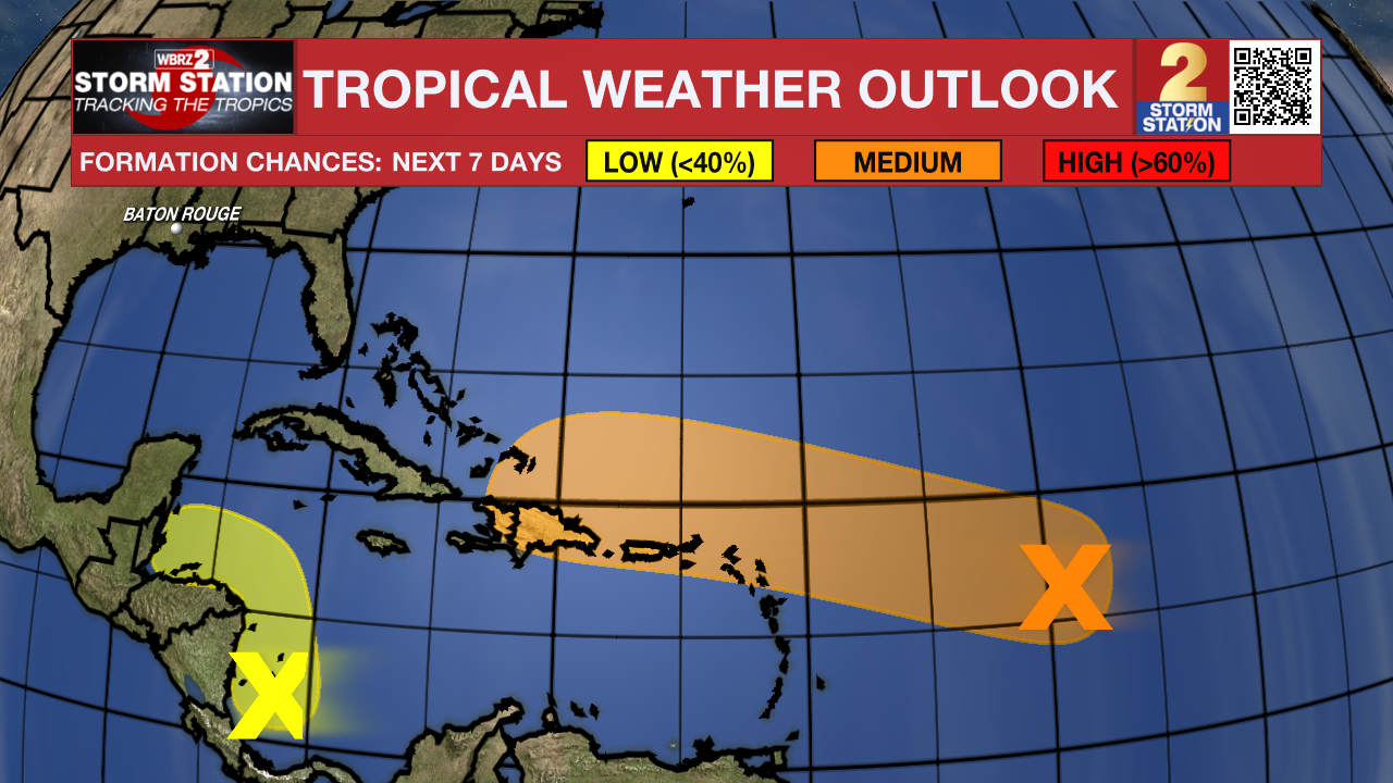
Showers and thunderstorms over the southwestern Caribbean Sea are associated with a broad area of low pressure. Some gradual development is possible if the system stays over water while it moves slowly northwestward toward Central America. Regardless of development, locally heavy rainfall is possible across portions of Central America and southern Mexico later this week and into the weekend.
– Josh
The Storm Station is here for you, on every platform. Your weather updates can be found on News 2, wbrz.com, and the WBRZ WX App on your Apple or Android device. Follow WBRZ Weather on Facebook and Twitter for even more weather updates while you are on the go.
More News
