

Latest Weather Blog
Friday PM Forecast: layers needed for big temperature swings from morning to afternoon
A gradual moderating trend will continue through the weekend. Rain remains a very hard find.
Tonight & Tomorrow: A few high clouds will be in skies tonight but enough to have a substantial effect on sensible weather. Low temperatures will stop a few degrees higher than previous nights, in the low 50s for most. However, some neighborhoods north of Baton Rouge could revisit the 40s. Any high clouds should thin out on Saturday giving way to a warming sun. High temperatures will top out in the low 80s with a light, east wind.
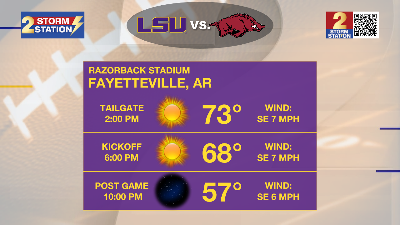
Football Forecasts: The Friday Night Blitz is looking like a picture perfect fall football evening. With mostly clear skies, temperatures will settle into the 60s during the games. Take a layer to add. On The Bluff, Southern Homecoming couldn’t ask for much better weather. Some light layers may be wanted for morning and evening but tailgating and afternoon festivities will have sun and temperatures in the low 80s. LSU fans hitting the road can expect clear and chilly conditions in Fayetteville. Temperatures will move from the mid 40s around dawn to mid 70s in the afternoon and retreat into the 60s and 50s during the game. The LSU Football Kickoff Weather Index shows the Tigers have won 61% of October night games on the road with temperatures under 70 degrees.
Up Next: Sunday will be sunny and seasonable with lows in the mid 50s and highs in the mid 80s. By early next week, gradual temperature moderation will continue and highs should be firmly in the mid to upper 80s with lows in the mid to upper 50s. There are signs that some high level clouds will start to spill into skies by Tuesday. Enough warming should occur to even allow some low topped cumulus to develop Wednesday through Friday. Still, no rain is in the forecast. Additionally, no significant cold fronts are expected through the end of next workweek.
Trending News
Get the latest 7-day forecast and real time weather updates HERE.
Watch live news HERE.
The Tropics: Recent satellite-derived wind data indicate that a trough of low pressure continues to produce showers and thunderstorms extending a couple hundred miles north of Puerto Rico and the Virgin Islands. Development, if any, of this disturbance should be slow to occur while it moves quickly westward to west-northwestward at around 20mph, continuing north of Puerto Rico and the Virgin Islands today, then near Hispaniola and the southeastern Bahamas this weekend. Further development is not expected due to strong upper-level winds by early next week.
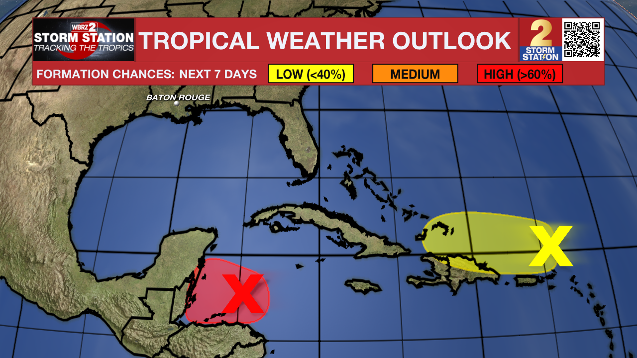
Widespread showers and thunderstorms have become a little better organized today across the northwestern Caribbean Sea in association with a broad area of low pressure that is gradually becoming better defined to the north of eastern Honduras. Environmental conditions appear conducive for some additional development over the next day or so, and a short-lived tropical depression or storm could form before the system moves inland over Central America on Saturday. Interests in Belize and the Yucatan Peninsula of Mexico should monitor the progress of this system, as tropical storm watches or warnings may be required later today. Regardless of development, locally heavy rainfall is likely across portions of Central America and southern Mexico through the weekend.
– Josh
The Storm Station is here for you, on every platform. Your weather updates can be found on News 2, wbrz.com, and the WBRZ WX App on your Apple or Android device. Follow WBRZ Weather on Facebook and Twitter for even more weather updates while you are on the go.
More News
