

Latest Weather Blog
LATEST: EXTREME COLD WARNING issued, one county placed in ICE STORM WARNING
The weather will be very active the next few days as a storm system sweeps across the south. While it will be mainly a rain event for most, pockets of freezing rain will start to be possible early Sunday, especially northwest of Baton Rouge.
BREAKDOWN OF ACTIVE ALERTS BELOW... DETAILED FORECAST FOLLOWS
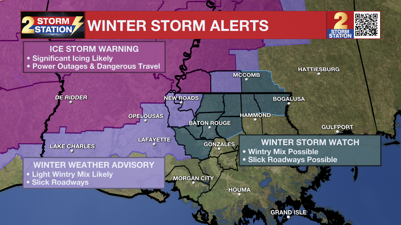
An ***ICE STORM WARNING*** will go into effect for Wilkinson County from midnight to 3pm Sunday. Accumulating ice will cause dangerous travel and my lead to power outages.
A ***WINTER WEATHER ADVISORY*** will go into effect for Pointe Coupee, West Feliciana, and Amite County also on Sunday. This is where areas of mixed precipitation, including freezing rain is more likely.
A ***WINTER STORM WATCH*** will go into effect for East Baton Rouge, West Baton Rouge, Northern Livingston, Iberville, East Feliciana, St. Helena, and Northern Tangipahoa Parishes, as well as Amite County on Sunday. This region highlights the "rain/freezing rain battleground" where there might be a changeover to freezing rain on Sunday. The watch area matches expectations for higher ice potential north and west of the I-10/12 corridor. Ice totals have trended lower, with only a light glaze expected where freezing rain occurs.
Trending News
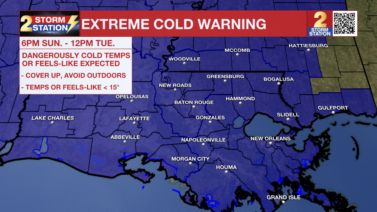
Additionally, an ***EXTREME COLD WARNING***will go into effect at 6pm Sunday and last until 12pm Tuesday for all of southeast Louisiana and southwest Mississippi. Dangerously cold wind chills as low as 4°F are expected. Frostbite and hypothermia will occur if unprotected skin is exposed to these temperatures. An extended period of freezing temperatures could cause ruptured water pipes.
Dress in layers including a hat, face mask, and gloves if you must go outside. To prevent water pipes from freezing; wrap or drain or allow them to drip slowly. Keep pets indoors as much as possible. Make sure outdoor animals have a warm, dry shelter, food, and unfrozen water. Make frequent checks on older family, friends, and neighbors. Ensure portable heaters are used correctly. Do not use generators or grills inside. If you do not have heat in your home or lack shelter, you can call 211 for assistance locating appropriate shelter from the cold. Use caution while traveling outside. Wear appropriate clothing, a hat, and gloves.

Winter Storm: A broad winter storm will sweep across the southern U.S. this weekend, bringing a mix of snow, ice, and rain along its path. The Baton Rouge metro sits near the southern edge of the potential ice zone, meaning we’re close enough that impacts remain something to watch closely.
Rain and possibly a few embedded thunderstorms will spread across Louisiana and Mississippi throughout the day Saturday. Any early dry breaks will be short-lived, with rain becoming more widespread by the afternoon and evening. Temperatures are expected to stay above freezing during the day, so icing issues are not anticipated locally on Saturday.

Use the slider to advance through the next 24 hours of Futurecast
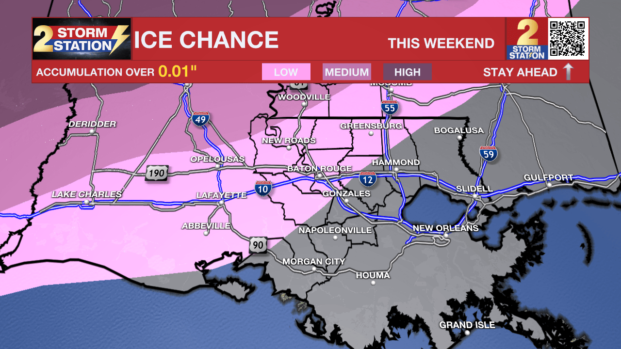
Periods of rain will linger Saturday night and into Sunday as colder air continues pushing south. Northwest winds will gradually force the freezing line closer to the Capital Area. If temperatures slip to 32° or below, any lingering rain would change over to freezing rain — a transition that could begin as early as Sunday morning. The highest chance of that freezing line arriving while rain is still falling will be along and north of a New Roads–to–McComb line. Along the I-10 and I-12 corridor, the threat is lower, and it drops off significantly farther south and east. Light icing would mainly create travel problems, but amounts exceeding a tenth of an inch could begin to weigh down trees and power lines. That higher-end risk remains focused north and west of Baton Rouge.
A minor change from just 32° to 33° makes a major difference in impacts for an event like this, so monitor Storm Station forecasts as new information comes in each hour. Be prepared to change or cancel travel plans this weekend. Follow the freeze line with us, by tracking the temperatures in the maps section of the Storm Station App.
Precipitation will come to an end by Sunday afternoon. Even so, temperatures are expected to fall below freezing Sunday night, meaning any leftover moisture could freeze — especially on bridges and elevated roadways. The good news is that stronger winds Sunday evening may help reduce how widespread those icy spots become. Generally, roads would need about 4 hours of time to dry given the cold, damp and windy conditions while bridges would need about 6 hours. An earlier end time to precipitation would likely result in very little freezing or ice on roadways while a later end time would likely result in at least some icy patches Sunday night into Monday.
Up Next: The cold will tighten its grip on Sunday night. North winds of 10-20 mph will send wind chills, or feels-like temperatures, plummeting into the single digits and teens by Monday morning. While some sun will come out for the afternoon, most locations will stay in the 30s through the day. By Tuesday morning, air temperatures will fall back into the upper teens, but fortunately, wind will not create a much lower feels-like temperature. With another afternoon of sun, thermometers will break into the 40s. Temperatures will remain chilly through midweek, though the heart of the cold will be on its way out by then.
Get the latest 7-day forecast and real-time weather updates HERE.
Watch live news HERE.
The Storm Station is here for you, on every platform. Your weather updates can be found on News 2, wbrz.com, and the WBRZ WX App on your Apple or Android device. Follow WBRZ Weather on Facebook and X for even more weather updates while you are on the go.
More News
